 |
|||||||||||||||||||||||||||||||
 |
|||||||||||||||||||||||||||||||
 |
 |
||||||||||||||||||||||||||||||
|
|
|||||||||||||||||||||||||||||||
| ■コース情報 | |||||||||||||||||||||||||||||||
|
|||||||||||||||||||||||||||||||
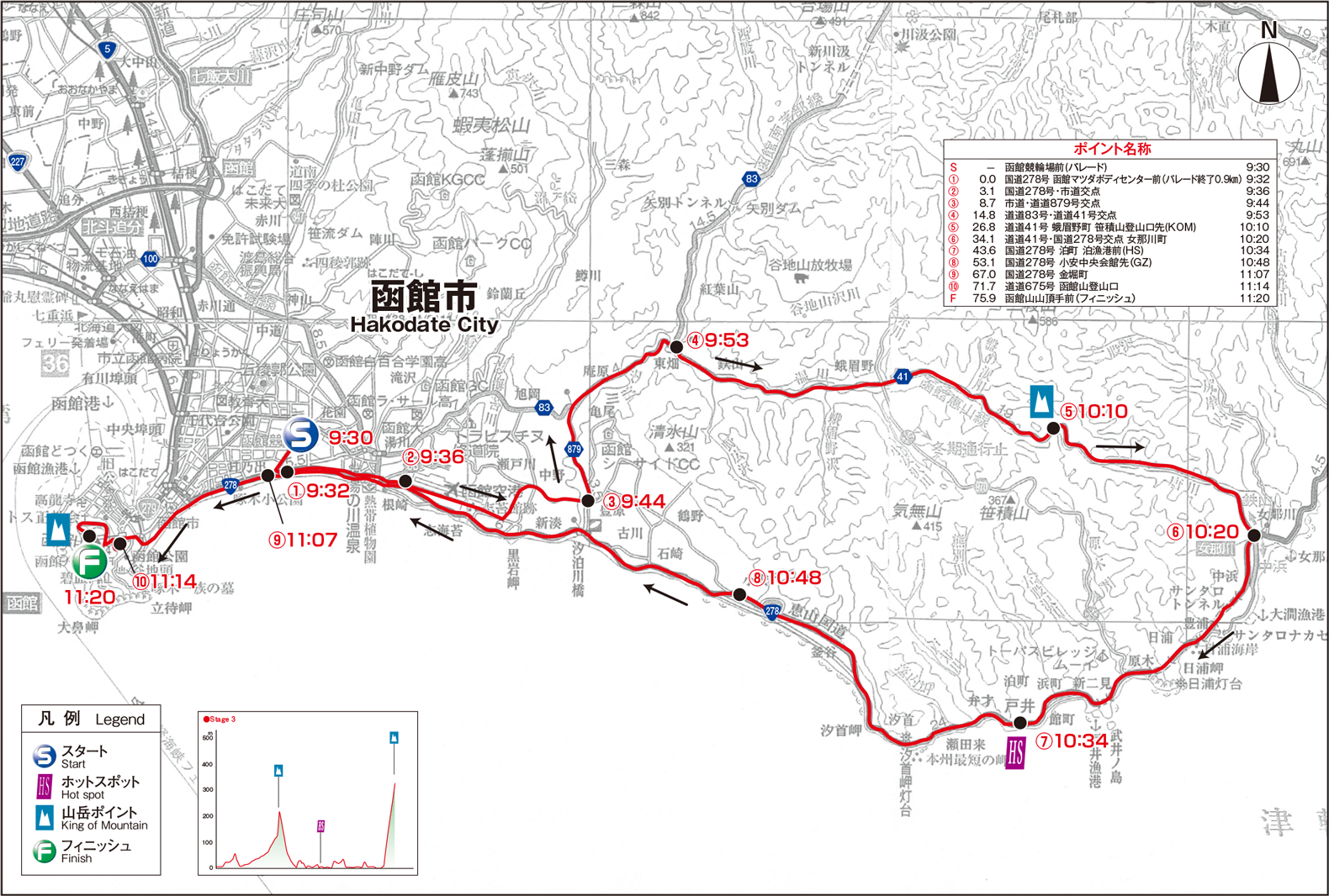
| ◇STAGE 3 函館市函館競輪場前 - 函館市函館山山頂 77Km ロードレース 9/10(日) | |||||||||||||||||||||||||||||||
|
September 10 (Sun.) Stage 3 : 77km (Road Race) Hakodate City ~ Hakodate City
|
|||||||||||||||||||||||||||||||
| 第3ステージコース概要図 | |||||||||||||||||||||||||||||||
|
|||||||||||||||||||||||||||||||
|
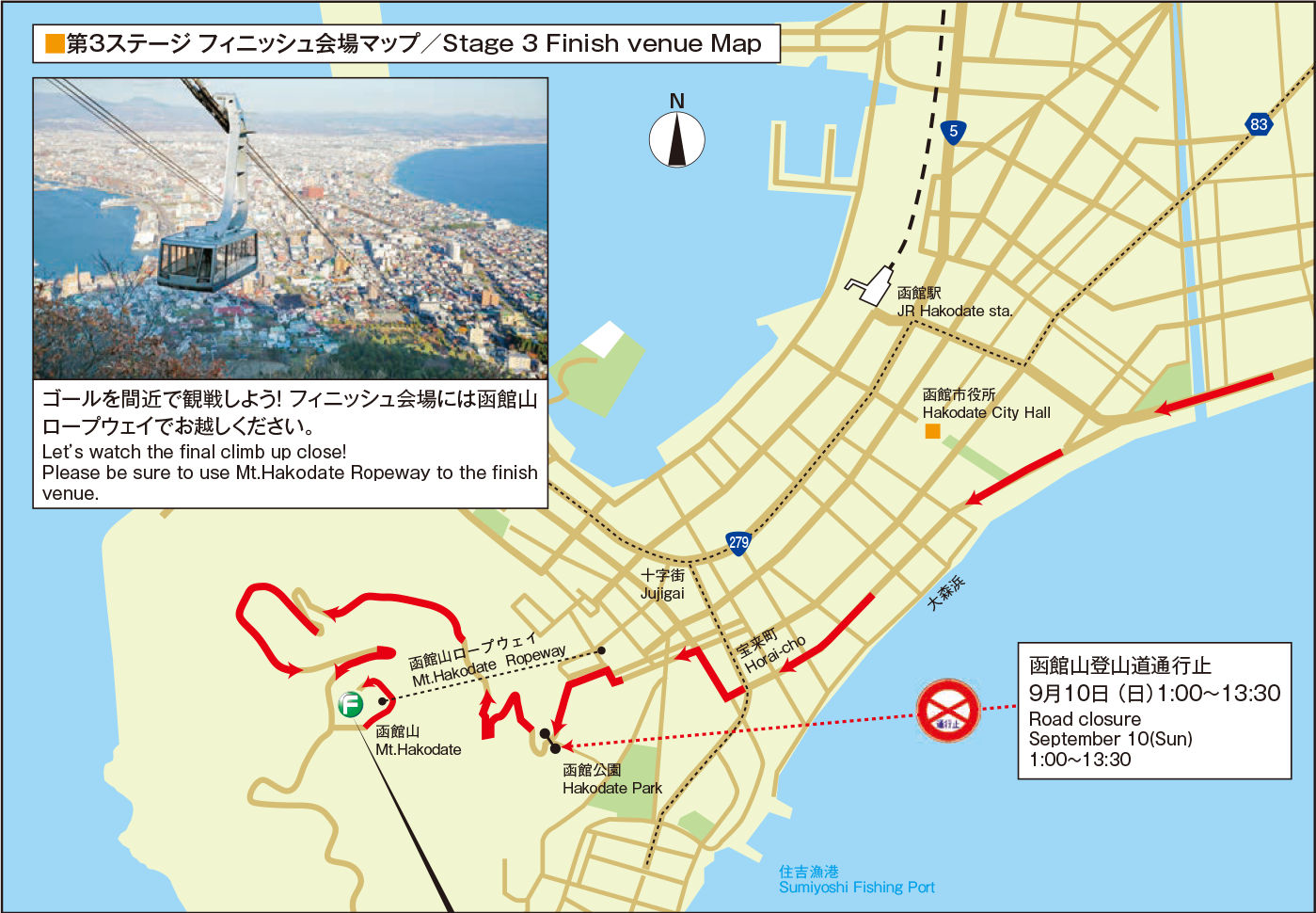
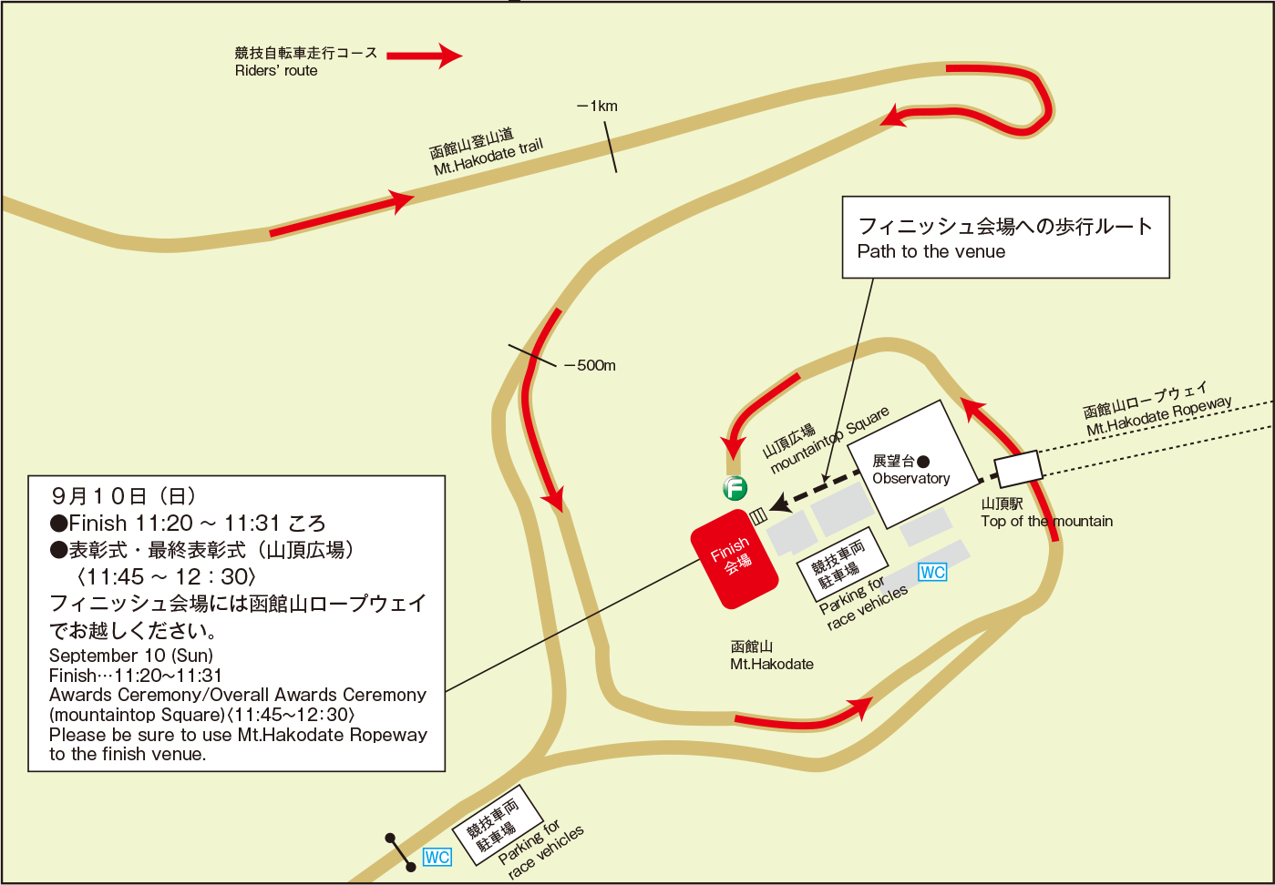
第3ステージは、函館市(函館競輪場前)からスタートし、湯の川温泉街から旧戸井線を通って函館空港滑走路下のボックスカルバートをくぐり、道道879号(米原古川線)、道道83号(函館南茅部線)を走って鉄山町から道道41号(函館恵山線)に入ります。 笹積山(ささづもりやま)登山口先(標高217m地点)で本ステージ最初の山岳ポイントを競った後、女那川町(めながわちょう)から国道278号を函館市街方向に右折しサンタロトンネル、日浦トンネルなど4つの連続するトンネルを抜けて、泊漁港前で中間スプリントを競います。 さらに走ると左手に津軽海峡、前方には函館山の絶景を望みながら平坦基調の海岸線コースを疾走し、大森海岸(漁火通)まで走ると函館山が目前に迫ってきます。 高田屋嘉兵衛像前から護国神社坂を駆け上り函館山登山道入口に入るとラスト4㎞。 ヘアピンカーブが連続する平均勾配6.4%の函館山登山道が最後の勝負どころ。 函館山山頂(標高326m地点)において最後の山岳ポイントを競うと同時にゴールとなり、本大会の覇者が決まる感動のシーンを迎えます。 第3ステージは、走行距離こそ77㎞と長くはないが、函館山登山道を登るのは大会史上初であり注目のコースです。 |
|||||||||||||||||||||||||||||||
|
Stage 3 starts and finish in Hakodate City. Starting in front of Hakodate Keirin Velodrome, the riders pass through Yunokawa Hot Spring area and go underneath the runway of Hakodate Airport through box culvert. The first KOM (king of mountain) is installed at the entrance of Mt. Sasatsumori. 4 consecutive tunnels on National Route 278 follows and there comes the Hot Spot (intermediate spring point) in front of Tomari Port. With the magnificent view of Tsugaru Strait on the left and Mt. Hakodate on front, relatively flat course along coastline goes on to Isaribi-dori, getting close to Mt. Hakodate. By the time we see the statue of Takadaya Kahei and Gokokujinja-zaka Slope on the course, it is 4km to the finish line, the second KOM at the top of Mt. Hakodate (altitude: 326m) after the steep climb. The trail up Mt. Hakodate (gradient average: 6.4%) with hairpin curves can decide the exciting outcome of the race. It is worth noting that 77-km course of Stage 3 features the trail up Mt. Hakodate for the first time in the history of Tour de Hokkaido.
|
|||||||||||||||||||||||||||||||
|
◇第3ステージコース図
|
|||||||||||||||||||||||||||||||
 |
|||||||||||||||||||||||||||||||
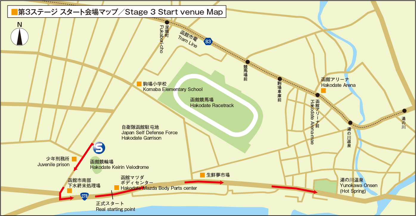 |
交通アクセス(Access) ●9/10(日)第3ステージ スタート地点:函館市 函館競輪場前 ◆JR函館駅前3番乗り場からバスで約10分「競輪場通」 下車、徒歩5分 ◆函館空港からバスで約15分「競輪場通」下車、徒歩5分 ◆函館市電「深堀町」下車、徒歩約15分 フィニッシュ地点:函館市 函館山山頂 ※交通規制により函館山登山道へ車両の乗り入れができま せんので、函館山ロープウェイをご利用ください。 ◆函館山ロープウェイ「山麓駅」から乗車3分、徒歩3分 ◆函館市電「十字街」下車、「山麓駅」まで徒歩10分、 ロープウェイ乗車3分、徒歩3分 ◆JR函館駅前から「山麓駅」まで約2㎞、車で約7分、 ロープウェイ乗車3分、徒歩3分 |
||||||||||||||||||||||||||||||
 |
|||||||||||||||||||||||||||||||
| ●September10(Sun)Stage3 Start:HakodateKeirinVelodrome,HakodateCity Bus: From JR Hakodate sta. (bus stop No. 3)… Get off at “Keirinjo-dori” (10 min.) and 5-min. walk From Hakodate Airport… Get off at “Keirinjo-dori” (15 min.) and 5-min. walk Tram: 15-min. walk from “Fukabori-cho” Finish:ThetopofMt. Hakodate,HakodateCity (3min.-ridebyMt.HakodateRopeway) Mt. Hakodate Ropeway “the foot of mountain” sta. Tram: From “Jujigai” sta. … 10 min-walk Car: From JR Hakodate sta. …7min. (2km) Please note to use Mt. Hakodate Ropeway since all vehicles are not allowed to enter the trail due to the traffic restriction |
|||||||||||||||||||||||||||||||
 |
|||||||||||||||||||||||||||||||
|
◇関係市町村の紹介(公式HPへ)
|
|||||||||||||||||||||||||||||||
 |
|||||||||||||||||||||||||||||||